


2020-09-01 montagne Mandallaz

Lucquiaud
User
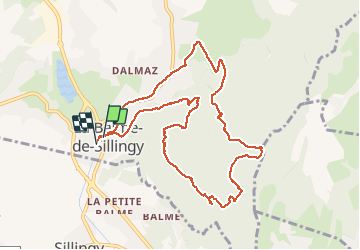

Length
10.7 km

Max alt
896 m

Uphill gradient
427 m
Km-Effort
16.4 km

Min alt
480 m

Downhill gradient
429 m
Boucle
Yes
Creation date :
2020-09-01 08:04:47.972
Updated on :
2020-09-01 12:41:19.645
4h35
Difficulty : Easy

FREE GPS app for hiking
 SityTrail
IGN / Geographical institutes
SityTrail Plus
The world is yours!
About
Trail Walking of 10.7 km to be discovered at Auvergne-Rhône-Alpes, Upper Savoy, La Balme-de-Sillingy. This trail is proposed by Lucquiaud.
Positioning
Country:
France
Region :
Auvergne-Rhône-Alpes
Department/Province :
Upper Savoy
Municipality :
La Balme-de-Sillingy
Location:
Unknown
Start:(Dec)
Start:(UTM)
270648 ; 5093906 (32T) N.
Comments